Master courses
Motivation
Global change research is a challenging field, in which satellite image analysis is of core importance to advance our knowledge on the changing Earth system. The strength of remote sensing lies in detecting and monitoring changes of the Earth and quantifying such processes over long time spans and large areas. Satellite data provides unique opportunities to map the environment and land-related attributes across a variety of spatial and temporal scales.
In our remote sensing courses, students learn to analyze satellite images for geographic research questions. Currently there is one module entirely dedicated to remote sensing (MSc 5.2) at the master level and several modules relating to it methodologically (e.g. MSc1) or thematically (e.g. MSc3).
Master courses
Earth Observation (MSc5.2, elective compulsory)

This module provides students with advanced knowledge of remote sensing methods. In the seminar, students learn theory, concepts and methods of environmental monitoring and analysis of terrestrial ecosystems. A specific focus lies on land cover and land use. Students will accordingly conceptualize methodological frameworks that match the investigated process regimes (and that will be implemented in the computer seminar of the module). In the computer seminar, students will perform PC-based analyses with digital image processing systems. The advanced research questions targeted here are jointly developed in the accompanying seminar. Students will be exposed to ongoing research, through which they will embed current remote sensing approaches in applied scientific analyses. Case studies can focus on two main research areas in geography: agricultural landscapes and forests. The different regional foci will align with the research projects conducted in the Earth Observation Lab and could include, for example, Central and Eastern Europe, Latin America or Central Asia.
- Prerequisites: MSc1 (Quantitative Methods) and MSc3 (Global Land Use Dynamics)
Quantitative Methods for Geographers (MSc1, compulsory)

The students describe, explain and systematise different advanced statistical and mathematical approaches to the quantitative analysis of geo- and environmental data and the modelling of human-environment systems, e.g. methods of applied and multivariate statistics and mathematical modelling. On the basis of the acquired theoretical and exemplified knowledge, the students apply existing approaches independently and adapt them to specific problems where necessary. They develop scientific research questions in the fields of data analysis and modelling and, using their acquired skills in applied programming, plan and implement their own analyses.
Global Land Use Dynamics (MSc3, compulsory)

In this module, students acquire a sound understanding of the role of land use in the earth system and as a driver and outcome of global change, as well as the close link between land use and key current sustainability challenges. Students are familiarized with the theoretical foundation and methodological tools to analyse land systems and their dynamics across scales and in an integrated fashion. Students deepen their skills to understand and assess the primary literature, and to summarize and critically discuss research results. The course participants develop their own research questions and develop and present the concepts needed to assess these questions.
Advanced Earth Observation (MSc6/7/8, elective)
We regularly, offer elective courses to that deepen your methodological skills in remote sensing, while addressing interesting research topics including ecosystem dynamics, food security, and urban sciences. Check out the course schedule for up-to-date information.Geoprocessing in Python (MSc6/7/8, elective)

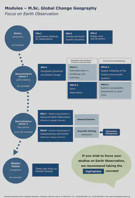
Recommended course schedule
The Earth Observation Lab recommends the following study plan when focussing on Earth Observation in your Master of Science “Global Change Geography” studies.

