Bachelor courses

The Earth Observation Lab offers courses for Bachelor of Science (B.Sc.) and Bachelor of Arts (B.A.) students from all study programs in the Department of Geography. The topics covered span a wide range of geographic research questions, primarily focused on physical geography and land system science, but often relevant to economic geography, as well as urban and rural planning. Students can choose from a combination of compulsory and elective courses, depending on the regulations of their study program. If you’re interested in specializing in remote sensing during your Bachelor’s studies, you can refer to the recommended schedule and course descriptions below, or consult with our staff to develop an individual study plan.
Please also take a look at the thesis writing section if you are considering writing your thesis in the Earth Observation Lab.
Bachelor courses
Introduction to Remote Sensing
German: Einführung in die Geofernerkundung
This course introduces students to basic concepts of remote sensing and its application in various fields of geography. Students learn how to design a remote sensing study for a geographic research question, how to acquire and analyse the image data, and how to interpret the results. The integration of additional geodata sources and the use of remote sensing products in GIS projects are exemplified.
- Prerequisites: Statistics, Introduction to GIS
- B.Sc. (2018): mandatory
- B.Sc./B.A. (2014): optional (highly recommended for those advancing to M.Sc. Global Change Geography)
Study project
German: Studienprojekt-Felderhebungen und Fernerkundung
Here, students learn how to set up their own research project, apply methods to assess land cover and land use changes from various remote sensing data sets and get detailed insights into planning and conducting practical field work. The study project is based on a well defined research question, carefully determined through the students’ literature reviews. Photo: Kira Pfoch
- Prerequisites: Introduction to Remote Sensing
- B.Sc.: optional (recommended for students with interest in bachelor thesis in applied remote sensing)
- B.A.: optional
Remote sensing for monitoring land systems
German: Vertiefungsmodul Vegetationsfernerkundung
The monitoring and mapping of vegetation and land cover is one of the key activities in Earth observation (EO). Advanced EO products are pivotal for many geographic and environmental studies. In this module students learn concepts and techniques for analyzing and mapping land cover and its characteristics at various spatial scales and with different sensor systems. Data analysis is done fully in R, and students learn to create customized R-scripts along a series of processing tasks throughout the semester.
- Prerequisites: Introduction to Remote Sensing
- B.Sc.: optional (recommended especially for students with interest applied programming and bachelor thesis in methods of remote sensing)
- B.A.: optional
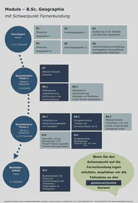
Recommended course schedule
The Earth Observation Lab recommends the following study schedule when focussing on Earth Observation in your Bachelor of Science studies.